
Freedom of Information Request
At the Woodside Hall public consultation on 4 March 2026, Transport Scotland displayed findings from a traffic modelling study for Approach 3: Remove. We were concerned that the modelling had been constructed to show the worst possible outcome for removal — simply taking the M8 out of the network with no replacement road, public transport investment, or any other mitigation.
We submitted a Freedom of Information request asking Transport Scotland to explain their methodology. Their reply confirmed our concerns. The model "replicates current traffic flows, congestion and delays to journey times, as observed, to develop a baseline." Transport Scotland modelled congestion from simply removing the M8. They did not model replacing it with an urban road, nor investing the hundreds of millions of pounds that repair will cost in public transport instead.
Read the full response:
The Transport Scotland Consultation
We suggested respondents answer the questions in their own words. Here is what we recommended:
What are your current views?
The temporary repairs have cost a phenomenal amount of public money — £150m after the latest increase. Transport Scotland need to provide a fully costed remove option with a ground-level road.
Approach 1: Repair the existing viaducts
I do not support this due to costs and environmental impact. The money should be invested in public transport.
Approach 2: Replace the Woodside Viaducts with a new structure
I do not support this due to costs and environmental impact. The money should be invested in public transport.
Approach 3: Remove this stretch of the M8 and redirect traffic
I support this option and want the viaduct to be replaced with a high-capacity urban boulevard that serves all modes of transport.
Extra questions
Suggestions for the area around and under the viaducts?
Respondents could express support for public transport improvements, and better walking, wheeling, and cycling infrastructure.
How do the M8 and local roads affect your journeys?
Respondents could talk about how the M8 severs connections between parts of the city, forcing long detours for journeys that should be short and direct.
About the consultation
This consultation is on the future of the Woodside Viaduct, a crumbling 1960s elevated motorway that cuts off North and North West Glasgow from the city centre. Temporary propping works that were meant to take 2 years and cost £35m will now take at least 6 years and £150m.
Transport Scotland asked for our opinion on three options: Repair the viaduct for up to £200m extra, replace it for up to £500m extra, or remove it for under £125m.
For comparison Strathclyde Partnership for Transport say it would cost an initial £300m to create a world-class bus service as good as any in Europe for the entire region.
Transport Scotland's consultation document claims that removing the motorway causes the most pollution, even though the exact opposite happened when other cities removed urban motorways.
We asked respondents to support Option 3: Remove, and to demand that Transport Scotland model building a replacement urban road for the entire city centre section of the M8 and spending the money saved on public transport.
A boulevard for Glasgow
Where the M8 currently carves a concrete trench through the heart of the city, we envision a tree-lined urban boulevard with space for light rail, cycling, and walking — reconnecting communities severed for over fifty years.

A restored Anderston and Kingston (image by Replace the M8)
Other cities have done it
Seoul, South Korea
When Seoul removed the Cheonggyecheon expressway and replaced it with a park and stream restoration, traffic actually improved. Property values rose, air quality got better, and the area became one of the city's most loved public spaces.


Cheonggyecheon, Seoul: before and after expressway removal.
Providence, Rhode Island
In Providence, the relocation of Interstate 195 removed a six-lane highway that had cut the city's Jewelry District off from downtown for decades. The project freed over 26 acres of prime urban land for redevelopment. Where there was once a concrete barrier, there are now new neighbourhoods, parks, and a reconnected waterfront. The project proved that removing urban motorways doesn't cause traffic chaos.

Providence, Rhode Island: before and after Interstate 195 removal.
What was lost at New City Road
Once a thriving neighbourhood crossroads with trams, tenements, and street life, St George's Cross and New City Road were obliterated to make way for the M8.
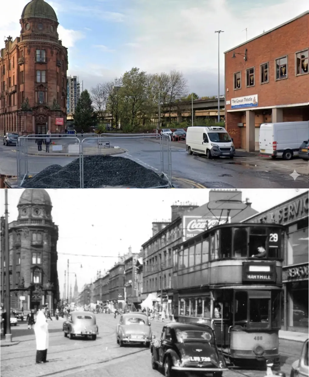
New City Road, before and after the M8. (images by Replace the M8 and Andrew Crichton)
Glaswegians tried to stop it
When the motorway was forced through Glasgow's communities, residents protested against the destruction of their neighbourhoods. Their warnings went unheeded. Now, over fifty years later, we finally have an opportunity to heal the scar they fought against.
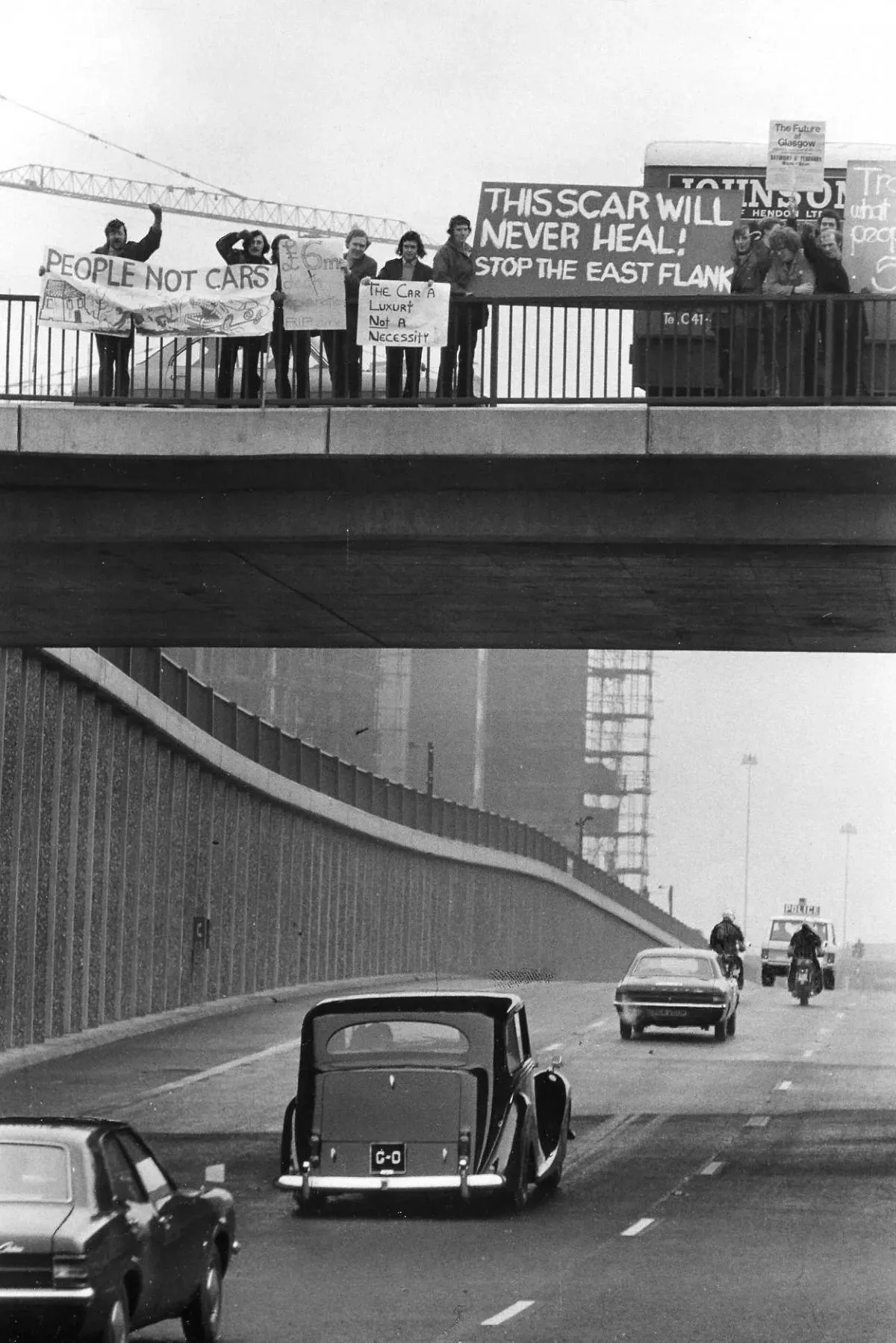
Historic protest against the M8 motorway construction in Glasgow.
Thousands of new homes on unlocked land
Removing the motorway and its interchanges frees vast areas of city-centre land for housing, parks, and mixed-use development. 3D modelling shows the scale of what's possible — reconnecting Anderston, Garnethill, and Cowcaddens with the rest of the grid.

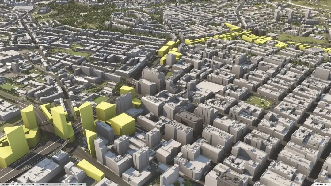
Visualisations of new housing and roads (images by Replace the M8)

